 Jahangir's World Times First Comprehensive Magazine for students/teachers of competitive exams and general readers as well.
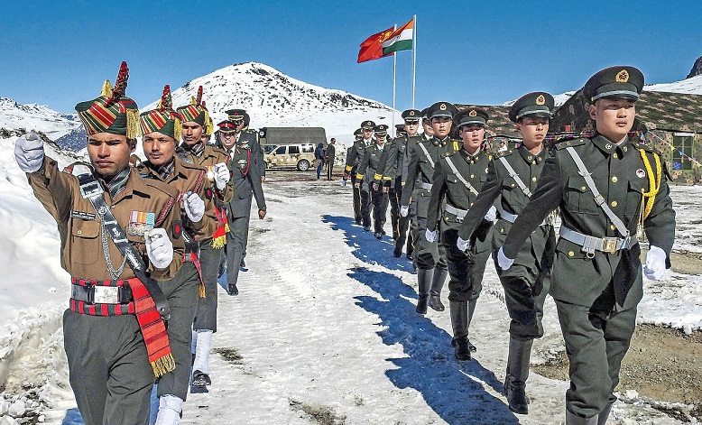
Line of Actual Control
With China’s growing military presence at the Line of Actual Control (LAC), a 4,057-km porous border running through glaciers, snow deserts, mountains and rivers separate India and China, tensions in the Himalayas have flared again in recent weeks, giving birth to a fear that the jostling could turn into an unintended full-blown military action.
Introduction
The Line of Actual Control (LAC) is the demarcation that separates Indian-controlled territory from Chinese-controlled territory. It runs at 15,000ft above sea level along an undefined border that stretches thousands of kilometers from Kashmir at one end, and Myanmar on the other. India considers the LAC to be 3,488 km long, while the Chinese consider it to be only around 2,000 km. It is divided into three sectors: the eastern sector which spans Arunachal Pradesh and Sikkim, the middle sector in Uttarakhand and Himachal Pradesh, and the western sector in Ladakh.
What is the disagreement?
The alignment of the LAC in the eastern sector is along the 1914 McMahon Line, and there are minor disputes about the positions on the ground as per the principle of the high Himalayan watershed. This pertains to India’s international boundary as well, but for certain areas such as Longju and Asaphila. The line in the middle sector is the least controversial but for the precise alignment to be followed in the Barahoti plains.
The LAC is a lengthy international frontier with three main sectors — eastern (Sikkim), western (Ladakh) and central (Nepal) — each having peculiar legal features. The Indian position on border disputes is surprisingly contradictory in all three sectors whereas China has implemented a consistent policy to assert the executive authority of its government over the chunks of land it claims all along the length of the LAC.
The major disagreements are in the western sector where the LAC emerged from two letters written by Chinese Prime Minister Zhou Enlai to his Indian counterpart, Jawaharlal Nehru, in 1959, after he had first mentioned such a ‘line’ in 1956. In his letter, Zhou said the LAC consisted of “the so-called McMahon Line in the east and the line up to which each side exercises actual control in the west”.
After the 1962 War, the Chinese claimed they had withdrawn to 20 km behind the LAC of November 1959. Zhou clarified the LAC again after the war in another letter to Nehru: “To put it concretely, in the eastern sector it coincides in the main with the so-called McMahon Line, and in the western and middle sectors it coincides in the main with the traditional customary line which has consistently been pointed out by China”. During the Doklam crisis in 2017, the Chinese Foreign Ministry spokesperson urged India to abide by the “1959 LAC”.
Conflict-resolution Efforts
Small-scale clashes have not been unusual since 1962, when the two sides fought the Himalayan war over territorial integrity. Since then, Beijing and New Delhi have signed a number of agreements to avert any major escalation.
China and India have signed four agreements on this boundary issue. These agreements were signed in September 1993, November 1996, April 2005 and October 2013. Indian & Chinese bilateral talks on border disputes is held on the basis of these four agreements. However, these agreements are considered to be flawed and are unable to resolve the boundary issue between the countries. Have a look at the details of these four agreements:
|
Year |
Agreement |
Flaw |
|
September 1993 |
Maintenance of peace & tranquility along LAC No activities of China and India will overstep the LAC |
These agreements are away from ground reality. There is no mention of the actual line location. There is no mention of line that separates deployment of India & Chinese troops |
|
November 1996 |
Chalks out measures to build confidence in military field along the LAC Both sides to limit their military forces within the agreed geographical zones |
|
|
April 2005 |
Political Parameters & Guiding Principles |
First three stages are complete and fourth one is ongoing. The 4th stage involves demarcation of boundary on map and ground |
|
October 2013 |
Border Defence Cooperation |
– |
When did India accept the LAC?
The LAC was discussed during Chinese Premier Li Peng’s 1991 visit to India, where PM PV Narasimha Rao and Li reached an understanding to maintain peace and tranquillity at the LAC. India formally accepted the concept of the LAC when Rao paid a return visit to Beijing in 1993 and the two sides signed the Agreement to Maintain Peace and Tranquillity at the LAC. The reference to the LAC was unqualified to make it clear that it was not referring to the LAC of 1959 or 1962 but to the LAC at the time when the agreement was signed. To reconcile the differences about some areas, the two countries agreed that the Joint Working Group on the border issue would take up the task of clarifying the alignment of the LAC.
Difference between LOC and LAC
|
Line of Control (LOC) |
Line of Actual Control (LAC) |
|
The Line of Control (LOC) is a 450 mile-long military control line which serves as a frontier slicing the disputed Indian and Pakistani governed parts of Kashmir into two. According to the United Nations, the LOC came into effect in July 1972, after India and Pakistan fought a war that began in 1971. They signed the Simla Agreement to define what was previously called the “ceasefire line.” The LOC isn’t a legally recognized boundary because it was meant to be a provisional international border which was agreed upon by both countries in the 1972 agreement.
|
Line of Actual Control (LAC) is the effective military border which separates Indian controlled areas of Jammu and Kashmir from Aksai Chin. It is the effective border between People’s Republic of china and India. It is nearly 4,057 km long. It touches Jammu and Kashmir, Uttarakhand, Himanchal and Sikkim of Indian states. This border is not a legally recognized international boundary, but rather it is the practical boundary. This term LAC got legally recognized during Sino-Indian agreements which were signed in 1993 and 1996.
|
Facts
According to the western sector maps shared by India and China in 2002 on their respective claim line, there are 12 areas of differences in perception of the Line of Actual Control. The maps were never exchanged due to Chinese objections.
These are:
- Samar Lungpa 176 sq km
- Trig heights and Depsang bulge 972 sq km
- Konh Ka La (3 pockets) 56 sq km
- Pangong Tso (Both banks) 83 sq km
- Spanggur Gap 24 sq km
- Mount Sajum 129 sq km
- Dumchele 40 sq km
- Demchok 150 sq km
- Chumar 80 sq km